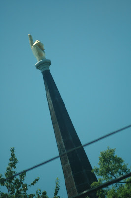
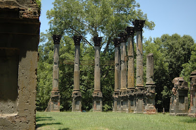
 I'd seen a picture of this church steeple before (in MS magazine). It's the steeple on the Presbyterian church. Kinda cool I think. We did a little iPhone searching and remembered there were several ghost towns in the region we'd heard about on Mississippi Roads. We also remembered that Windsor Ruins (wiki link) were nearby too... The address of Windsor is not navigable by google maps or our GPS. We found it anyway. Cool place. I'd never been there. Wes had though. It was destroyed by fire when somebody left a cigar burning in 1890, causing it to burn to the ground! Tragic considering it survived the war.


 Notice the iron rails still attached where the upper floor porch used to be. Pretty cool. While we were there, this man asked us if we had been there before. He said the staircase from the house is being used at the chapel on the campus of Alcorn State University.


 Here's the staircase at Alcorn's Chapel. The iron rails were also from the house.
We decided to look for the Ghost Towns nearby (according to Wiki). Rodney was the first one. We knew Rocky Springs was nearby too. Rodney wasn't that easy to find. The road that would lead us there was HWY 552. It split off and then turned into a gated private property. We had to go back to Alcorn State (which is really in the middle of nowhere! Why would anyone want to go to school there??!) and find our way through campus to a road that would lead us to Rodney. There was construction at Alcorn which made it difficult to figure out where to go. We found the road....it was dirt. We'll more like an old logging road/trail that hadn't been driven in 50 years! It was terrible! I felt like some redneck hunter in dirty overalls was gonna come out with a rifle like a troll and make us pay to pass or something.... It was that bad! (I should also say we were in the car too). The road eventually got better, then worse, then better again... We were truly in the sticks!
 We finally found Rodney. (wiki page) The road went from gravel, to dirt and back a few times. Then is suddenly turned to paved with curbs and gutters and everything. It was nice, but the thing was, it hadn't been touched in years. Grass was overtaking the pavement. Their was this huge pile of dirt/grass/whatever in the middle of the lane. It was weird. Then it turns back into dirt and whalla... there's the "town." This is the Presbyterian church. The one where the "battle" took place (read the links above).


 Here's a shot through the window. The wiki page says there are still services here. Looks like there are new floral arrangements in front. The white tassel is the pull for the bell.
 Notice the cannonball in the wall above the window.
 This is the Baptist church.
 This was a commercial building back in the day.
 I think this was an old corner store. It was next to the main road. Notice the old gas pump.
 After finding out way back to civilization, we headed towards Natchez. We wanted to find Rocky Springs, but it was 4pm already and we had no idea where it was. (photos) There was little to no cell service so we couldn't search for it. It obviously didn't show up on the GPS. Maybe next time, we'll find it.... Here's a few pictures of Natchez. We didn't do much. Just drove around a little and then ate at a restaurant on the river.


1 comment:
What a great collection of photos. You discovered some unique places!
Post a Comment